Bournillon and Choranche: The Extraordinary Journey of a Drop of Water Turbined Twice
From the colossal porch of the Bournillon cave to the arch dam at Choranche, the Bourne gorges shelter a masterpiece of circular engineering. Between the memory of the 1893 pioneers, underground tunnels, and a cascade of power stations, discover the fascinating history of a site where the Vercors makes a single drop of water generate electricity twice.
The Vercors: a limestone fortress and the legendary birthplace of France’s “white coal.” Along the Bourne gorges, a singular spectacle unfolds between rock, water, and human ingenuity.
What if a single drop of water could spin turbines twice, in two different places within the same massif? That is the magic of the Bournillon-Choranche complex. Here stands a spectacular alliance between the Bournillon resurgence with its colossal porch and the arch dam at Choranche. Together they form a model of circular engineering and pioneering audacity, where gravity, karst rock, and human genius shaped the landscape of the Royans.
From the pioneers of 1893 to the great postwar construction sites, here is a journey along the Bourne’s hydroelectric network.
1. The Bournillon cirque: spectacular karst, underground mysteries, and the pioneers’ saga
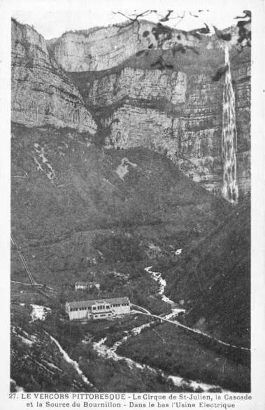
The Bournillon cirque is a natural setting quite unlike any other. Its vertical walls tower above the Moulin-Marquis waterfall, which drops nearly 400 meters and ranks among the highest in France. At the bottom of the cirque opens the porch of the Bournillon cave, considered one of the tallest cave entrances in Europe, somewhere between 100 and 120 meters high depending on which measurement you trust.
This imposing natural arch is the intermittent outlet of a monumental karst network, one of the largest in the Vercors. To this day, miles of flooded galleries and underground rivers remain shrouded in mystery, still being explored and mapped by cavers from around the world.
The finest example of this hidden circulation is the “underground Vernaison”: first identified deep inside the Luire cave, this invisible river resurfaces in the Bourne valley, both at the Arbois springs and at the Bournillon cave. Keep those two names in mind, because they are precisely two of the three drops that would feed the power station. The Bourne itself, rising at 1,050 meters in the Val de Lans, acts as the drain around which both surface runoff and karst circulation organize themselves across much of the massif, a massif generously watered with some 1,350 mm of precipitation a year. Its average flow is around 22 m³/s, yet its violent floods can approach 650 m³/s in a hundred-year event. The catchment, 27,000 hectares of almost unbroken forest without a single glacier, owes everything to its karst reserves: springs that never run dry, such as the Goule Noire and Arbois, emerge clear and at a constant temperature, so that the Bourne never freezes, even in the hardest cold. An advantage the pioneers of electricity would come to appreciate at its full value.
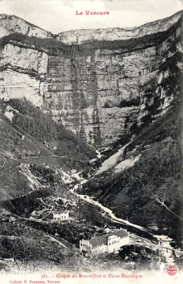
The white coal adventure (1893)
The power of the Bourne did not, in fact, wait for electricity: as early as the seventeenth century, sawmills, wood-turning shops, mills, oil presses, weaving sheds, and paper mills lined the valley. At the turn of the twentieth century, electrical energy came to supplant that direct water power. In 1893, according to local memory, the industrialist Chausson, based in Saint-Laurent-en-Royans, grasped the energy potential of this still-isolated valley and founded the Société des Forces Motrices du Vercors. Followed by other industrialists around the turn of the century, he laid the first groundwork.
The April 1905 issue of the journal La Houille Blanche, which devoted a long technical report to the brand-new plant, illuminates the other side of the story: it was a group of industrialists from Vienne, led by Messrs. Bouvier and Laurent and assisted by the engineer C. Simon, who launched the project “a little before 1900,” initially to supply lighting and motive power to their own city. The major milestones then followed in quick succession:
- 1903-1904: the Bournillon hydroelectric plant comes into being by capturing the Arbois springs. It first supplies Romans, then Vienne and Beaurepaire from late January 1905 onward, over a single 80-kilometer line.
- 1912: development of the high drop from the La Balme dam raises the head to 314 meters.
- 1952: tapping the resurgence of the Bournillon cave completes the ensemble, right in the era of the newly created EDF’s great construction campaigns.
🗂️ When the archives disagree: local memory credits Chausson with building the La Balme dam and its penstock as early as 1893; EDF documentation dates the first development capturing the Arbois springs to 1903; the journal La Houille Blanche describes, in April 1905, a plant that has been running “for about a year”; a heritage panel in Romans mentions 1908 for the “Bournillon dam”; while the French dam registry gives 1912 for the commissioning of the present-day structure at La Balme. Even the pioneers’ names vary: local memory remembers Chausson, while the 1905 journal salutes the initiative of Bouvier and Laurent of Vienne. Such discrepancies are common for works reshaped in stages across three decades: concessions, first water intakes, definitive structures, and later raisings pile up and blur together in the retelling. I have kept the operator’s own dates here, the most solid ones, while flagging the variants.
Contrary to a widespread belief, the Bournillon plant does not turbine water from the plateau: it turbines the waters of the Bourne and of its karst network. The large La Balme reservoir, built across the river, the Arbois springs, and the spectacular contribution of the Bournillon cave all converge on the plant through three distinct drops:
- The La Balme-de-Rencurel drop, taken at 624 meters of elevation behind a 24-meter gravity dam, giving 314 meters of head, the highest of the three.
- The Arbois drop, the oldest (1903): it gathers the Arbois springs at about 405 meters, one of the outlets of the underground Vernaison, giving roughly 95 meters of head based on present-day elevations (the 1905 journal announced “about 105 meters”).
- The Bournillon cave drop, the most recent (1952): it captures the cave’s intermittent resurgence at about 416 meters, giving roughly 106 meters of head. It only comes fully alive during floods, when it can discharge as much as 80 m³/s.
The Bournillon cave truly flows only during heavy rain or snowmelt. The rest of the year it often stands dry, which makes its contribution all the more precious, and all the more spectacular, when the floods arrive.
This electricity went on to transform daily life in the Royans: it brought power to the isolated farms of the Vercors, consigning kerosene lamps to the past, while giving the local economy a real boost, as sawmills, woodworking shops, and small mechanical workshops were able to expand production thanks to this clean and abundant energy.
2. The EDF Bournillon power station: 314 meters of head and the transformation of a site
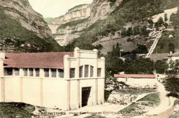
Tucked away at 310 meters of elevation at the bottom of the cirque, in the commune of Châtelus, the Bournillon station draws its strength from implacable physics. The main penstock, fed from the La Balme dam, delivers a net head of 314 meters. From the floor of the cirque you can still make out the long penstock plunging down the cliff, a permanent witness to that vertiginous drop.
On arrival, the pressure approaches 30 bar and strikes the nozzles of the Pelton turbines with carefully harnessed violence.
So what became of the pioneers’ very first plant? The original station from the early twentieth century was never demolished. Across decades of successive modernizations, the historic building was enlarged, restructured, and fully absorbed into today’s EDF industrial complex. Look closely at the site and you can still trace the architectural footprint of the pioneers beneath the modern extensions that now house state-of-the-art equipment.
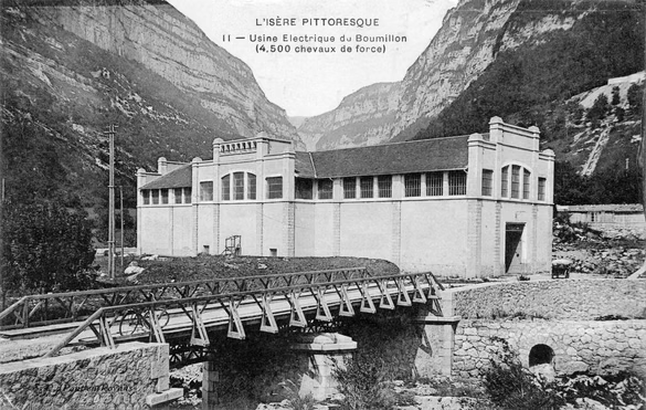
Here is a detail the old postcards give away: the advertised power jumped within a few years. The earliest printings boast “4,500 horsepower,” while later ones proudly announce “12,500 horsepower.” That near-tripling, from roughly 3.3 to 9 megawatts, corresponds precisely to the arrival of the high drop from La Balme around 1912: the pioneers’ plant, first fed by the Arbois drop alone, had changed scale entirely. The progression has continued since: with its three drops gathered “under one roof,” the station now reaches a maximum output of 26.6 MW.
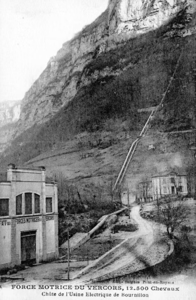
Today’s station draws one of its greatest strengths from its responsiveness: it can push electricity onto the grid very quickly when demand peaks. The water it has turbined is then returned to the bed of the Bourne, just upstream of where the Choranche dam now stands.
1905: a guided tour courtesy of La Houille Blanche
We have an exceptional account of the plant in its early days: in April 1905, E.-F. Côte, editor in chief of the journal La Houille Blanche, devoted a full technical report to it. The plant was then a year old, and the picture he paints is striking. In this “deserted place,” reached from Pont-en-Royans by “a poor road” whose steep climbs and dangerous descents made hauling equipment a nightmare, stood a machine hall 63 meters long by 16 wide, where three units of 1,250 horsepower each were turning. More telling still, the building was sized for six units: the high drop from La Balme, built in 1912, and its reservoir had been planned from the very start. The postcards charting the tripling of power were therefore telling a story that had been written in advance.
The hydraulic works first. A masonry intake dam was built just below the Arbois springs, in a picturesque narrows of the gorge overhung by the road from Pont-en-Royans to Villard-de-Lans, complete with a scouring gate to flush out sand and gravel and a screen to keep floating debris out. With the walls of the gorge running nearly vertical, no open canal could be hung along them: a headrace tunnel 1,800 meters long was cut into the rock, 1.80 meters by 2, a cross-section dictated not by the water but by the room the workmen needed while boring it. Along its course lay a settling chamber, likewise hewn from the rock, and a spillway whose overflow tumbles back into the Bourne “in a magnificent waterfall more than 50 meters high.” The surge chamber, nestled at the foot of a towering rock wall, keeps 1.50 meters of freeboard to absorb a sudden shutdown of the turbines.
The penstock is a small engineering masterpiece of its time: 350 meters long, a uniform 1.20 meters in diameter, sized for 3,000 liters per second at 2.67 m/s, with friction losses capped at 2.5 percent of the head. Its Martin-Siemens steel plate, sourced from the Loire basin, thickens as the pressure rises, from 5 mm at the top to 9 mm at the bottom and 10 mm for the manifold, hot-riveted, caulked for watertightness, and fitted with manholes for inspection. One detail says much about the era: sliding expansion joints, which had caused accidents elsewhere, were banned outright; the builders preferred to anchor the pipe in masonry blocks calculated to absorb a 50-degree temperature swing, with the pipes sliding on their piers over steel plates coated in graphite grease. The whole thing was designed and installed by the Grenoble contractors Bouchayer and Viallet, and required a fresh coat of paint roughly every five years.
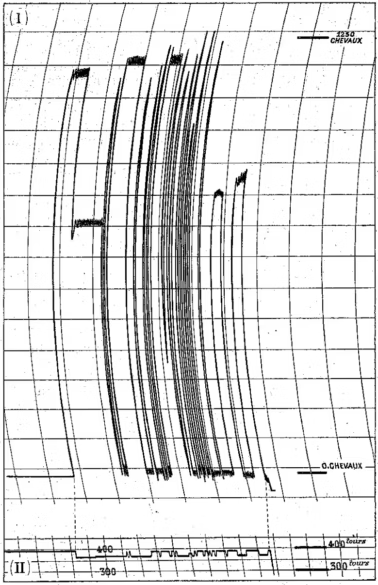
As for the machinery, the turbines built by the Grenoble engineers A. and H. Bouvier were of the centrifugal free-deviation type, with a clever trick known as hydropneumatization: a device injected air into the draft tube to recover 80 percent of the remaining height between the turbine and the tailrace. Their centerpiece was a single central governor, driven by a 50-horsepower synchronous motor, which controlled the gates of all three turbines at once through hydraulic servomotors. During the acceptance tests, conducted before an invited audience of engineers, full load was cut and restored abruptly: speed variations never exceeded 5 percent. A pressure regulator, a valve that opens sharply and closes very slowly, protected the penstock from water hammer, with overpressure limited to 10 percent.
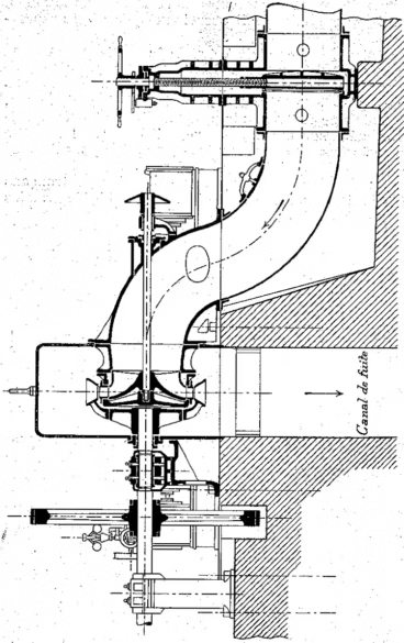
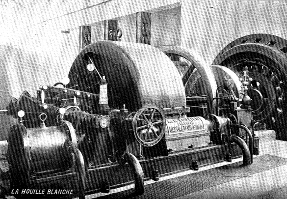
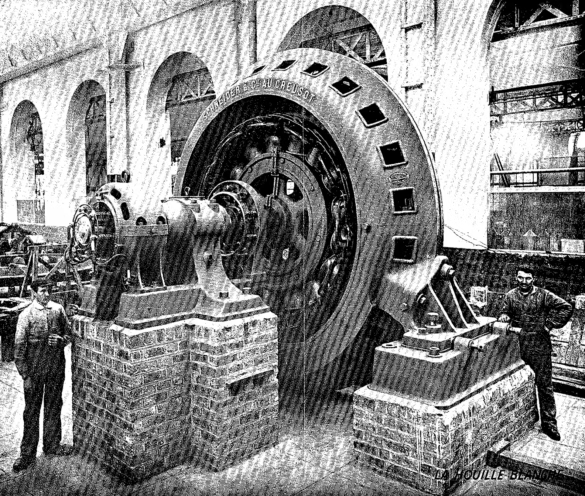
The electrical side, supplied entirely by Schneider et Cie, was every bit as impressive. Three alternators of 1,000 kVA at 3,800 volts, with 16 poles turning at 375 rpm to deliver 50-cycle current, achieved 92 percent efficiency; their stator rings could be rotated on rollers to make the windings accessible for repair. Six single-phase transformers of 580 kVA, arranged in two three-phase banks cooled by fans, stepped the voltage up to 35,000 volts, with intermediate taps at 30,000 and 32,500 volts to offset line losses as the transmitted load grew; their efficiency reached 98 percent and their insulation was tested at 50,000 volts. From a gallery overlooking the hall, white marble switchboards concentrated the instruments and controls, protected by two sets of lightning arresters, one mushroom type and one horn type. And to light itself, the plant had its own small direct-current generator, 430 amperes at 70 volts, driven by a dedicated 45-horsepower turbine, which doubled as a backup exciter.
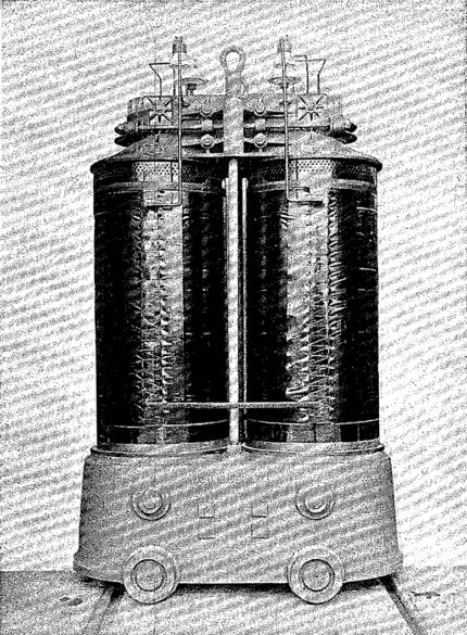
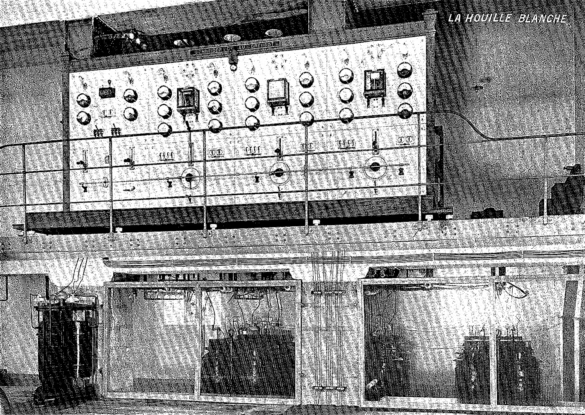
That left the matter of delivering the current. A single three-phase line some 80 kilometers long ran toward Vienne and Romans on wooden poles, shielded from lightning by a twisted wire strung with barbed wire along the top of the poles and grounded every fifth pole. The plant initially ran at more than 30,000 volts to supply Romans alone, then dropped back to 20,000 or 21,000 volts in star connection in order to serve Vienne and Beaurepaire as well. It is worth pausing on what this meant in 1905: just two plants, Bournillon and Avignonnet on the Drac, were feeding the entire fledgling regional grid, each able to stand in for the other when needed, and despite the length of the line and the very high voltage, the journal reported only “brief and very infrequent outages.”
⚡ The prophecy of 1905: Côte counted four developable drops on the Bourne, from Les Jarrands to Choranche, amounting to “about 8,000 horsepower,” or nearly 6 MW, and predicted that all of this energy would readily find a use. The scheme already called for a second compensating reservoir at the plant’s outlet, alongside the multi-million-cubic-meter reservoir at La Balme, in order to regulate the river: the very idea that would become, half a century later, the Choranche dam. One hundred and twenty years on, the basin’s five developments total 69 MW, more than ten times his forecast. Even the visionaries were aiming too low.
📊 The 1905 plant by the numbers
| Specification | Value in 1905 |
|---|---|
| Drop in service | Arbois, “about 105 meters,” average flow 2,500 L/s |
| Headrace tunnel | 1,800 m, section 1.80 × 2.00 m, cut into the rock |
| Penstock | 350 m, 1.20 m dia., steel plate 5 to 9 mm, 3,000 L/s |
| Machine hall | 63 × 16 m, sized for 6 units |
| Units installed | 3 × 1,250 horsepower (A. and H. Bouvier turbines) |
| Alternators | Schneider, 1,000 kVA, 3,800 V, 16 poles, 375 rpm, 50 Hz |
| Transformers | 6 × 580 kVA, stepping 3,800 to 35,000 V, 98 percent efficiency |
| Transmission line | 80 km, three-phase, wooden poles, up to 35,000 V |
| Towns supplied | Romans, then Vienne and Beaurepaire (January 1905) |
3. The Choranche dam (1948-1950): the quiet giant that generates nothing on site
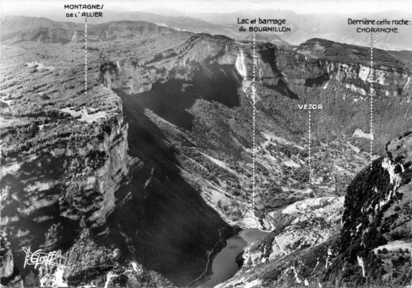
After the Second World War and the 1946 nationalization of electricity, France embarked on a vast program of reconstruction works. Between 1948 and 1950 the Choranche dam rose: an elegant thin concrete arch 25.4 meters high and 163 meters long, founded on Cretaceous marly limestone, with its crest at 307.5 meters of elevation. The complete development, tunnel included, occupied the contractors from 1946 to 1950.
It holds back the waters of the Bourne at the foot of the cirque and creates a 12-hectare reservoir storing up to 1.05 million cubic meters, of which 730,000 m³ are live storage, at the outlet of a 250 km² catchment. This reservoir collects not only the river’s own flow but also the water discharged by Bournillon and the Arbois resurgences.
📜 Memories of the construction site: this great postwar project left a deep mark on local memory. The workers were housed in prefabricated camps on the site of what is now the Choranche campground, as well as in the buildings still standing beside the Hôtel Continental at Choranche-les-Bains, and they brought the village to life.
A regulating dam… nowhere near its power station
Contrary to received wisdom, the Choranche dam does not turbine water on site. Its role is purely to regulate and store the resource.
The water is swallowed into an underground tunnel 5.7 kilometers long (5,756 meters to be exact, with a cross-section of 10.75 m²) cut straight through the rock, capable of carrying up to 27.8 m³/s, then into a penstock 243 meters long and 2.50 meters in diameter, all the way to the Pont-en-Royans power station. There, under a head of 109 meters, two double Francis turbines generate electricity a second time, roughly 96 GWh a year, carried to the grid by 63,000-volt lines, before the water is finally returned to the river.
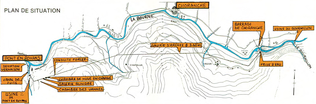
The Pont-en-Royans station works in hydropeaking mode: in the cold season, Choranche’s live storage lets it generate during peak hours, when demand is highest; in summer, the reservoir helps regulate the flow of the Bourne canal for irrigation. It thus acts as a buffer between the peaking output of Bournillon upstream and the regulated generation downstream.
4. The water’s secret journey: a cascade of ingenuity
The layout of this double generation is a perfect illustration of the ingenuity behind the Royans hydroelectric complex:
- Upstream: the water of the Bourne, impounded at the La Balme dam and supplemented by the Arbois and cave resurgences, reaches the Bournillon plant → first pass through the turbines under a maximum head of 314 meters → returned to the Bourne.
- Midway: the water is held back by the Choranche dam → channeled into the 5.7-kilometer underground tunnel.
- Downstream: arrival at Pont-en-Royans → second pass through the turbines under 109 meters of head → final return to the river’s natural bed.
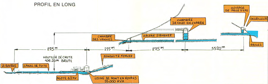
Why turbine the water twice rather than once? Because a turbine extracts only the energy of a given drop, never that of the river’s entire descent. Leaving Bournillon, the water has already “spent” its 314 meters of elevation, but the whole slope down to Pont-en-Royans still lies ahead: energy that would dissipate in mere eddies if it were simply allowed to run off. The Choranche dam catches it and sends it down for a second fall. This is the principle of cascade development, in which each plant exploits its own stretch of the river’s profile.
That second intake carries another decisive advantage: between La Balme and Choranche, the Bourne is enriched by the Bournillon resurgence, the Arbois springs, and the whole intermediate catchment. A single pipeline running straight to Pont-en-Royans would have let all that extra flow escape. One amusing caveat to this article’s title: a drop that falls downstream of the cirque will only ever know Pont-en-Royans, whereas one that came by way of La Balme or the cave really is turbined twice.
This route belongs to a wider set of five hydroelectric developments in the Bourne basin: Bournillon (1903, high drop in 1912, cave in 1952, 26.6 MW), the Bourne station, fed by the Les Jarrands dam at the mouth of the gorges (1919, 7 MW), Goule Blanche, which taps a resurgence deep in a cave (1933, 4.2 MW), Bouvante, on the Lyonne, a tributary of the Bourne (1926, completely refurbished in 1965, 9 MW), and Pont-en-Royans (1950, 22.5 MW). According to EDF documentation, the twelve Pelton and Francis units across the system total 69 MW of maximum output and produce 283 GWh in an average year. Operation, maintenance, and monitoring for the entire basin are run from Pont-en-Royans.
👁️ A construction secret to spot on your next walk: to drive the 5.7-kilometer tunnel through the cliff, the workers opened “windows” in the rock face. Those openings, still clearly visible from the Bourne gorges road (RD531), were used to haul out spoil, ventilate the works, and create intermediate access points.
5. Environmental record, heritage, and advice for visitors
The Choranche reservoir sits remarkably well in the landscape, its water often tinted an intense emerald green at the foot of the limestone cliffs.
EDF maintains a continuous minimum flow in the bed of the Bourne. That reserved flow ensures the survival of the brown trout and limits the impact on the river’s biodiversity, even though this stretch remains heavily engineered. In summer, the reservoir also plays a valuable role in supplying the Bourne canal, which irrigates several thousand hectares of the Valence plain.
📍 Viewpoints not to be missed
- The bridge over the Bourne: the ideal spot to photograph the elegant curve of the Choranche arch dam.
- The hike up to the Bournillon porch: to feel the sheer force of the terrain, take in the Moulin-Marquis waterfall, and stand dreaming before the entrance to the underground world (mind the safety instructions issued by the Vercors Regional Natural Park).
- The Bourne gorges road (RD531): to play detective and spot the old spoil windows cut into the cliff.
In Pont-en-Royans, a visit to the Musée de l’Eau rounds out the tour perfectly, retracing the fascinating history of white coal throughout the valley. Since 2018 one of its rooms has even housed an EDF exhibition on hydroelectricity in the Vercors and the lower Isère.
Conclusion
From the pioneers’ dream, Chausson on the Royans side, Bouvier and Laurent on the Vienne side, to the great postwar works, the Bournillon-Choranche site distills everything poetic about white coal in France. It shows how human engineering learned to read a complex karst landscape in order to transform local life and tame the force of the elements. “Honor to those who do not throw in the towel,” wrote E.-F. Côte in 1905, saluting pioneers who were then mocked for an enterprise “deemed fanciful.” History has proved him right.
The adventure did not stop at the Bourne gorges, incidentally: buoyed by its success in the Royans, the Société des Forces Motrices du Vercors extended its work across the whole basin, with the La Plaine station at Bouvante in the 1920s, on the Lyonne, a tributary of the Bourne, fed by the artificial lake of the same name, before reaching beyond the massif altogether by winning the concession for the Pizançon dam on the Isère. That story would be worth an article of its own.
On my last walk there, I was struck by the silence at the foot of the Choranche dam, in such contrast with the power of the water it holds. It is a place where engineering makes itself discreet and leaves the grandeur of the Vercors all the room it needs.
Today, in the context of the energy transition, these medium-sized works are a reminder that there is such a thing as hydroelectricity rooted in a territory: discreet, flexible, and deeply woven into the landscape.
📊 Technical summary
| Structure / Site | Bournillon power station | Choranche dam and Pont-en-Royans power station |
|---|---|---|
| Commissioned | 1903 (Arbois) / 1912 (La Balme) / 1952 (cave) | Dam 1948-1950, full development 1946-1950 |
| Type of structure | High-head hydroelectric plant (original building absorbed into the complex) | Thin concrete arch dam, crest at 307.5 m, normal water level 305 m NGF |
| Upstream intakes | La Balme (624 m), Arbois (405 m), Bournillon cave (416 m) | Reservoir on the Bourne, 250 km² catchment |
| Height / Head | 3 drops: 314 m (La Balme), ~95 m (Arbois), ~106 m (cave) | Dam 25.4 m high and 163 m long; gross head of 109.20 m at Pont-en-Royans |
| Storage | No significant reservoir at the plant | 12 ha, 1.05 million m³, of which 730,000 m³ live storage |
| Water conveyance | Penstock from La Balme, about 30 bar at the nozzles | Tunnel of 5,756 m (section 10.75 m², including 205 m steel-lined, 27.8 m³/s), then a penstock 243 m long, 2.50 m dia. |
| Units and output | 26.6 MW across 3 drops, impulse turbines of the Pelton type | 2 horizontal-shaft double Francis units (13 MVA, 500 rpm), 22.5 MW, about 96 GWh/year |
| Strategic role | Responsive peaking generation | Storage, regulation, and conveyance; hydropeaking generation |
| Where the water goes | Returned to the Bourne, upstream of Choranche | Returned to the Bourne at Pont-en-Royans, after the second pass |